
Make a donation
Burgas topographic map
Click on the map to display elevation.
Make a donation
About this map
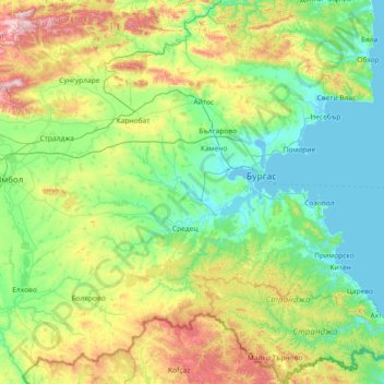
Name: Burgas topographic map, elevation, terrain.
Location: Burgas, Bulgaria (41.90441 26.57865 42.98470 28.03575)
Average elevation: 221 m
Minimum elevation: -4 m
Maximum elevation: 1,026 m
Make a donation
Other topographic maps
Click on a map to view its topography, its elevation and its terrain.
Vitosha
Due to a great variability in elevation, a rich diversity of climates, flora and fauna can be found within the park. Research has revealed that on the comparatively small area of the mountain there are 1,500 species of higher plants, 500 species of fungi, 500 species of algae, 326 species of mosses, and 200…
Average elevation: 2,105 m
Make a donation
Lovech
Lovech is situated in the Forebalkan area of northern Bulgaria, on both sides of the river Osam, and unifies both mountainous and plain relief. The eastern part of the town is surrounded by a 250 m high plateau, where the largest park in Lovech, Stratesh, is located, and the southwestern part is surrounded by…
Average elevation: 364 m