
Thank you for supporting this site ❤️
Make a donation
Make a donation
Molvízar topographic map
Click on the map to display elevation.
Thank you for supporting this site ❤️
Make a donation
Make a donation
About this map
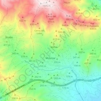
Name: Molvízar topographic map, elevation, terrain.
Average elevation: 423 m
Minimum elevation: 25 m
Maximum elevation: 1,066 m
Thank you for supporting this site ❤️
Make a donation
Make a donation
Other topographic maps
Click on a map to view its topography, its elevation and its terrain.
Peñon de Bodíjar
Spain > Andalusia > Comarca de la Costa Granadina > Los Guájares
Average elevation: 870 m
Thank you for supporting this site ❤️
Make a donation
Make a donation
Cortijo de Vegueta
Spain > Andalusia > Comarca de la Costa Granadina > Almuñécar
Average elevation: 211 m