
Thank you for supporting this site ❤️
Make a donation
Make a donation
Mirishkor tumani topographic map
Click on the map to display elevation.
Thank you for supporting this site ❤️
Make a donation
Make a donation
About this map
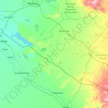
Name: Mirishkor tumani topographic map, elevation, terrain.
Average elevation: 301 m
Minimum elevation: 179 m
Maximum elevation: 1,202 m
Thank you for supporting this site ❤️
Make a donation
Make a donation
Other topographic maps
Click on a map to view its topography, its elevation and its terrain.
Chirakchi
Uzbekistan > Qashqadaryo Region > Chirakchi District
It is located on the Kashkadarya River, 12 kilometers from the Yakkabag railway station, and about 500 kilometers to the south of Tashkent. The city is situated in the southwestern foothills of the Zeravshan Range at an elevation of approximately 510 meters above sea level.
Average elevation: 528 m