
Thank you for supporting this site ❤️
Make a donation
Make a donation
Conakry topographic map
Click on the map to display elevation.
Thank you for supporting this site ❤️
Make a donation
Make a donation
About this map
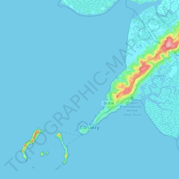
Name: Conakry topographic map, elevation, terrain.
Location: Conakry, Guinea (9.43219 -13.84029 9.75337 -13.47382)
Average elevation: 5 m
Minimum elevation: -1 m
Maximum elevation: 151 m
Thank you for supporting this site ❤️
Make a donation
Make a donation
Other topographic maps
Click on a map to view its topography, its elevation and its terrain.
Pita
Guinea > Mamou Region > Pita Prefecture
Th geographical coordinates of the town are 11°03'16.0"N, 12°23'46.0"W (Latitude:11.054444; Longitude:-12.396111). The town is located at an average elevation of 972.6 metres (3,191 ft) above mean sea level.
Average elevation: 937 m