
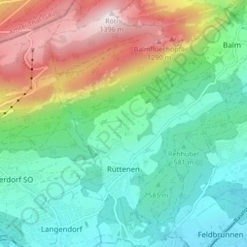
Rüttenen topographic map
Interactive map
Click on the map to display elevation.
About this map
Name: Rüttenen topographic map, elevation, terrain.
Average elevation: 740 m
Minimum elevation: 439 m
Maximum elevation: 1,392 m
Other topographic maps
Click on a map to view its topography, its elevation and its terrain.
Flumenthal
Suisse > Soleure > Amtei Solothurn-Lebern
Flumenthal, Bezirk Lebern, Amtei Solothurn-Lebern, Soleure, 4534, Suisse
Average elevation: 452 m
Kammersrohr
Suisse > Soleure > Amtei Solothurn-Lebern
Kammersrohr, Bezirk Lebern, Amtei Solothurn-Lebern, Soleure, 4535, Suisse
Average elevation: 644 m