
Pontaury topographic map
Interactive map
Click on the map to display elevation.
About this map
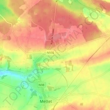
Name: Pontaury topographic map, elevation, terrain.
Location: Pontaury, Mettet, Namen, Wallonië, 5640, België (50.31812 4.64376 50.35812 4.68376)
Average elevation: 251 m
Minimum elevation: 205 m
Maximum elevation: 281 m
Other topographic maps
Click on a map to view its topography, its elevation and its terrain.
Saint-Gérard
België > Namen > Namen > Mettet
Saint-Gérard, Mettet, Namen, Wallonië, 5640, België
Average elevation: 237 m
Ermeton-sur-Biert
België > Namen > Namen > Mettet
Ermeton-sur-Biert, Mettet, Namen, Wallonië, 5644, België
Average elevation: 247 m