
Thank you for supporting this site ❤️
Make a donation
Make a donation
Ulah topographic map
Click on the map to display elevation.
Thank you for supporting this site ❤️
Make a donation
Make a donation
About this map
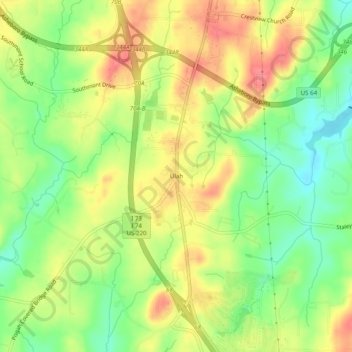
Name: Ulah topographic map, elevation, terrain.
Location: Ulah, Randolph County, North Carolina, 27205, United States (35.61541 -79.84670 35.65541 -79.80670)
Average elevation: 237 m
Minimum elevation: 201 m
Maximum elevation: 271 m
Thank you for supporting this site ❤️
Make a donation
Make a donation
Other topographic maps
Click on a map to view its topography, its elevation and its terrain.
Thank you for supporting this site ❤️
Make a donation
Make a donation
Thank you for supporting this site ❤️
Make a donation
Make a donation