Geolocate

Plainfaing topographic map

Interactive map

Click on the map to display elevation.

About this map

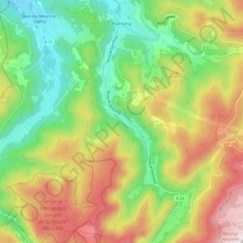
Name: Plainfaing topographic map, elevation, terrain.

Location: Plainfaing, Saint-Dié-des-Vosges, Vosges, Grand Est, Metropolitan France, 88230, France (48.10578 6.99724 48.18005 7.08446)

Average elevation: 815 m

Minimum elevation: 476 m

Maximum elevation: 1,292 m

Other topographic maps

Click on a map to view its topography, its elevation and its terrain.

Saint-Remy

France > Grand Est > Vosges

Saint-Remy, Saint-Dié-des-Vosges, Vosges, Grand Est, Metropolitan France, 88480, France

Average elevation: 363 m

Langley

France > Grand Est > Vosges

Langley, Épinal, Vosges, Grand Est, Metropolitan France, 88130, France

Average elevation: 292 m

Les Rangs

France > Grand Est > Vosges > Éloyes > Les Rangs

Les Rangs, Éloyes, Épinal, Vosges, Grand Est, Metropolitan France, 88510, France

Average elevation: 466 m

Le Ménil

France > Grand Est > Vosges

Le Ménil, Épinal, Vosges, Grand Est, Metropolitan France, 88160, France

Average elevation: 685 m

La Bresse

France > Grand Est > Vosges > La Bresse

La Bresse, Épinal, Vosges, Grand Est, Metropolitan France, 88250, France

Average elevation: 855 m