
Make a donation
Hanover Island topographic map
Click on the map to display elevation.
Make a donation
About this map
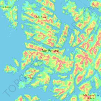
Name: Hanover Island topographic map, elevation, terrain.
Average elevation: 148 m
Minimum elevation: -3 m
Maximum elevation: 965 m
Make a donation
Other topographic maps
Click on a map to view its topography, its elevation and its terrain.
Cerro Torre
Chile > Magallanes and Chilean Antarctica Region > Provincia de Última Esperanza
Average elevation: 1,916 m
Cerro Torre
Chile > Magallanes and Chilean Antarctica Region > Provincia de Última Esperanza > Puerto Natales
Average elevation: 1,916 m
Cerro Ballena
Chile > Magallanes and Chilean Antarctica Region > Provincia de Última Esperanza
Average elevation: 400 m
Mirador Cóndor
Chile > Magallanes and Chilean Antarctica Region > Provincia de Última Esperanza > Torres del Paine
Average elevation: 140 m
Make a donation
Puerto Natales
Chile > Magallanes and Chilean Antarctica Region > Provincia de Última Esperanza
Average elevation: 141 m
Puerto Natales
Chile > Magallanes and Chilean Antarctica Region > Provincia de Última Esperanza
Average elevation: 141 m
Puerto Natales
Chile > Magallanes and Chilean Antarctica Region > Provincia de Última Esperanza
Average elevation: 141 m
Isla Cabrera
Chile > Magallanes and Chilean Antarctica Region > Provincia de Última Esperanza
Average elevation: 80 m
Make a donation
Puerto Natales
Chile > Magallanes and Chilean Antarctica Region > Provincia de Última Esperanza
Average elevation: 141 m
Valle Ascensio
Chile > Magallanes and Chilean Antarctica Region > Provincia de Última Esperanza > Torres del Paine
Average elevation: 1,060 m
Cerro Ballena
Chile > Magallanes and Chilean Antarctica Region > Provincia de Última Esperanza
Average elevation: 400 m
Puerto Natales
Chile > Magallanes and Chilean Antarctica Region > Provincia de Última Esperanza
Average elevation: 141 m
Make a donation