
Thank you for supporting this site ❤️
Make a donation
Make a donation
Seguin Township topographic map
Click on the map to display elevation.
Thank you for supporting this site ❤️
Make a donation
Make a donation
About this map
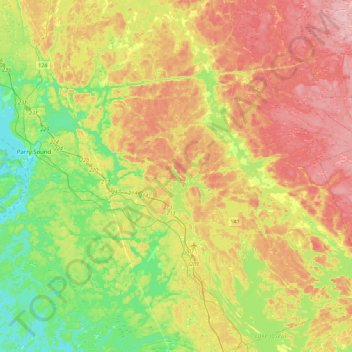
Name: Seguin Township topographic map, elevation, terrain.
Average elevation: 247 m
Minimum elevation: 172 m
Maximum elevation: 336 m
Thank you for supporting this site ❤️
Make a donation
Make a donation
Other topographic maps
Click on a map to view its topography, its elevation and its terrain.
Ludgate
Canada > Ontario > Parry Sound District > Unorganized Centre Parry Sound
Average elevation: 194 m
Black Bass Island
Canada > Ontario > Parry Sound District > The Archipelago Township
Average elevation: 202 m
Thank you for supporting this site ❤️
Make a donation
Make a donation
Byng Inlet
Canada > Ontario > Parry Sound District > Unorganized Centre Parry Sound
Average elevation: 193 m