
Thank you for supporting this site ❤️
Make a donation
Make a donation
Huacura topographic map
Click on the map to display elevation.
Thank you for supporting this site ❤️
Make a donation
Make a donation
About this map
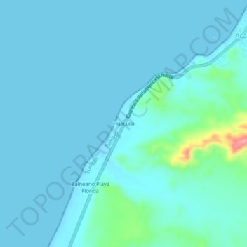
Name: Huacura topographic map, elevation, terrain.
Location: Huacura, Zorritos, Contralmirante Villar, Tumbes, Perú (-3.77266 -80.80813 -3.73266 -80.76813)
Average elevation: 13 m
Minimum elevation: 0 m
Maximum elevation: 122 m
Thank you for supporting this site ❤️
Make a donation
Make a donation
Other topographic maps
Click on a map to view its topography, its elevation and its terrain.