
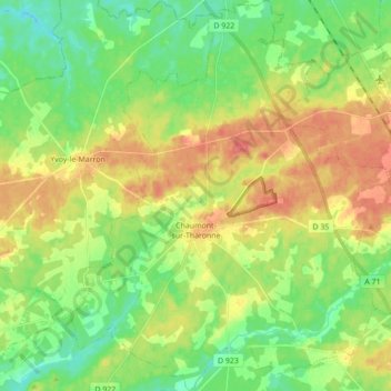
Chaumont-sur-Tharonne topographic map
Interactive map
Click on the map to display elevation.
About this map
Name: Chaumont-sur-Tharonne topographic map, elevation, terrain.
Average elevation: 117 m
Minimum elevation: 93 m
Maximum elevation: 148 m
Other topographic maps
Click on a map to view its topography, its elevation and its terrain.
Saint-Julien-sur-Cher
France > Centre-Val de Loire > Loir-et-Cher
Saint-Julien-sur-Cher, Romorantin-Lanthenay, Loir-et-Cher, Centre-Val de Loire, France métropolitaine, 41320, France
Average elevation: 120 m
Fougères-sur-Bièvre
France > Centre-Val de Loire > Loir-et-Cher > Le Controis-en-Sologne
Fougères-sur-Bièvre, Le Controis-en-Sologne, Romorantin-Lanthenay, Loir-et-Cher, Centre-Val de Loire, France métropolitaine, 41120, France
Average elevation: 97 m
Le Château
France > Centre-Val de Loire > Loir-et-Cher > Chambord
Le Château, Chambord, Blois, Loir-et-Cher, Centre-Val de Loire, France métropolitaine, 41250, France
Average elevation: 89 m
Château de Ronsard
France > Centre-Val de Loire > Loir-et-Cher > Vallée-de-Ronsard > Couture-sur-Loir > Le Grand Cimetière
Château de Ronsard, Allée de la Pléiade, Le Grand Cimetière, Couture-sur-Loir, Vallée-de-Ronsard, Vendôme, Loir-et-Cher, Centre-Val de Loire, France métropolitaine, 41800, France
Average elevation: 84 m
Les Rocheuses
France > Centre-Val de Loire > Loir-et-Cher > Villiers-sur-Loir
Les Rocheuses, Villiers-sur-Loir, Vendôme, Loir-et-Cher, Centre-Val de Loire, France métropolitaine, 41100, France
Average elevation: 95 m
Chambord
France > Centre-Val de Loire > Loir-et-Cher
Chambord, Blois, Loir-et-Cher, Centre-Val de Loire, France métropolitaine, 41250, France
Average elevation: 91 m
Blois
France > Centre-Val de Loire > Loir-et-Cher
Blois, Loir-et-Cher, Centre-Val de Loire, France métropolitaine, 41000, France
Average elevation: 95 m