
Thank you for supporting this site ❤️
Make a donation
Make a donation
Cairn of Claise topographic map
Click on the map to display elevation.
Thank you for supporting this site ❤️
Make a donation
Make a donation
Cairn of Claise
It has an elevation of 1,063.1 m (3,488 ft) and a prominence of 118.9 m (390 ft) and is a Munro.
Thank you for supporting this site ❤️
Make a donation
Make a donation
About this map
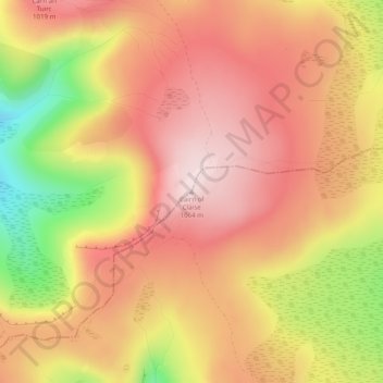
Name: Cairn of Claise topographic map, elevation, terrain.
Location: Cairn of Claise, Angus, Scotland, United Kingdom (56.89413 -3.33868 56.89423 -3.33858)
Average elevation: 919 m
Minimum elevation: 680 m
Maximum elevation: 1,060 m
Thank you for supporting this site ❤️
Make a donation
Make a donation
Other topographic maps
Click on a map to view its topography, its elevation and its terrain.
Thank you for supporting this site ❤️
Make a donation
Make a donation
Thank you for supporting this site ❤️
Make a donation
Make a donation
Thank you for supporting this site ❤️
Make a donation
Make a donation
Thank you for supporting this site ❤️
Make a donation
Make a donation