
Make a donation
Sankt Sigmund im Sellrain topographic map
Click on the map to display elevation.
Make a donation
Sankt Sigmund im Sellrain
Sankt Sigmund im Sellrain is a municipality in western Austria, in the district of Innsbruck-Land in the state of Tyrol located 23.3 kilometres (14.5 mi) southeast of Innsbruck, in the deepest part of the Sellrain Valley. It has a large area and the highest elevation. The main source of income is winter tourism.
Make a donation
About this map
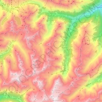
Name: Sankt Sigmund im Sellrain topographic map, elevation, terrain.
Average elevation: 2,289 m
Minimum elevation: 928 m
Maximum elevation: 3,268 m
Make a donation
Other topographic maps
Click on a map to view its topography, its elevation and its terrain.
Hoher Burgstall
Austria > Tyrol > Bezirk Innsbruck-Land > Neustift im Stubaital
Average elevation: 2,142 m
Make a donation
Make a donation
Elferspitze
Austria > Tyrol > Bezirk Innsbruck-Land > Neustift im Stubaital
Average elevation: 1,978 m
Make a donation
Make a donation
Axamer Lizum
Austria > Tyrol > Bezirk Innsbruck-Land > Gemeinde Axams > Axamer Lizum
Average elevation: 1,858 m
Make a donation