
Thank you for supporting this site ❤️
Make a donation
Make a donation
Kommunarka topographic map
Click on the map to display elevation.
Thank you for supporting this site ❤️
Make a donation
Make a donation
About this map
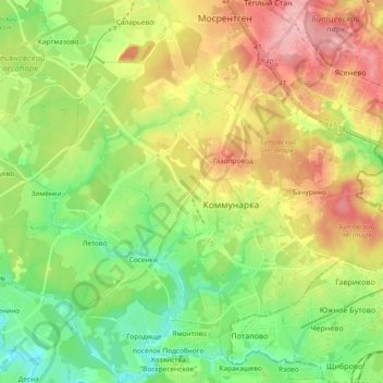
Name: Kommunarka topographic map, elevation, terrain.
Location: Kommunarka, Moskau, Föderationskreis Zentralrussland, Russland (55.49792 37.36827 55.63739 37.55480)
Average elevation: 185 m
Minimum elevation: 135 m
Maximum elevation: 257 m
Thank you for supporting this site ❤️
Make a donation
Make a donation
Other topographic maps
Click on a map to view its topography, its elevation and its terrain.
Moskau
Moskau wurde nach den Zerstörungen im Krieg wieder aufgebaut. Im Jahre 1947 fasste man den Beschluss, die Stadt an acht ausgewählten Standorten mit Hochhäusern zu versehen. Moskau hatte durch den Abriss zahlreicher Kirchen und Kathedralen sowie die nun allgemein höhere Bebauung nicht nur bedeutende…
Average elevation: 159 m