
Thank you for supporting this site ❤️
Make a donation
Make a donation
Cordova topographic map
Click on the map to display elevation.
Thank you for supporting this site ❤️
Make a donation
Make a donation
About this map
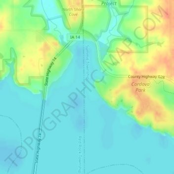
Name: Cordova topographic map, elevation, terrain.
Location: Cordova, Summit Township, Marion County, Iowa, United States (41.41756 -93.10966 41.43756 -93.08966)
Average elevation: 235 m
Minimum elevation: 220 m
Maximum elevation: 265 m
Thank you for supporting this site ❤️
Make a donation
Make a donation
Other topographic maps
Click on a map to view its topography, its elevation and its terrain.