
Make a donation
Wake County topographic map
Click on the map to display elevation.
Make a donation
Wake County
Wake County is located in the northeast central region of North Carolina, where the North American Piedmont and Atlantic Coastal Plain regions meet. This area is known as the "fall line" because it marks the elevation inland at which waterfalls begin to appear in creeks and rivers. As a result, most of Wake County features gently rolling hills that slope eastward toward the state's flat coastal plain. Its central Piedmont location situates the county about three hours west of Atlantic Beach by car and four hours east of the Great Smoky Mountains.
Make a donation
About this map
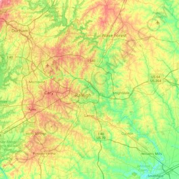
Name: Wake County topographic map, elevation, terrain.
Location: Wake County, North Carolina, United States (35.51946 -78.99507 36.07654 -78.25453)
Average elevation: 96 m
Minimum elevation: 30 m
Maximum elevation: 218 m
Make a donation
Other topographic maps
Click on a map to view its topography, its elevation and its terrain.
Make a donation
Royal Pines
United States > North Carolina > Buncombe County > Asheville > Royal Pines
Royal Pines is located in southern Buncombe County at 35°28′39″N 82°30′35″W / 35.47750°N 82.50972°W / 35.47750; -82.50972 (35.477386, -82.509833). It is bordered to the west by U.S. Route 25A and the city limits of Asheville, and to the northeast by Mills Gap Road. Brown Mountain, with an…
Average elevation: 700 m
Make a donation
Carmel Village
United States > North Carolina > Union County > Monroe > Carmel Village
Average elevation: 186 m
Olsen Homes
United States > North Carolina > Cleveland County > Shelby > Olsen Homes
Average elevation: 246 m
Brookwood Subdivision
United States > North Carolina > Alamance County > Burlington > Brookwood Subdivision
Average elevation: 198 m
Make a donation