
Thank you for supporting this site ❤️
Make a donation
Make a donation
Ujung Genteng topographic map
Click on the map to display elevation.
Thank you for supporting this site ❤️
Make a donation
Make a donation
About this map
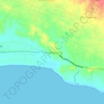
Name: Ujung Genteng topographic map, elevation, terrain.
Location: Ujung Genteng, Sukabumi, West Java, Java, Indonesia (-7.37445 106.42397 -7.33445 106.46397)
Average elevation: 19 m
Minimum elevation: 0 m
Maximum elevation: 67 m
Thank you for supporting this site ❤️
Make a donation
Make a donation
Other topographic maps
Click on a map to view its topography, its elevation and its terrain.