
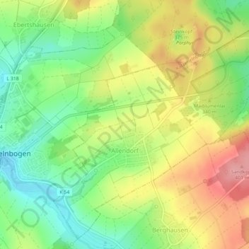
Allendorf topographic map
Interactive map
Click on the map to display elevation.
About this map
Name: Allendorf topographic map, elevation, terrain.
Average elevation: 334 m
Minimum elevation: 283 m
Maximum elevation: 394 m
Other topographic maps
Click on a map to view its topography, its elevation and its terrain.
Obernhof
Allemagne > Rhénanie-Palatinat > Rhein-Lahn-Kreis > Obernhof
Obernhof, Bad Ems-Nassau, Rhein-Lahn-Kreis, Rhénanie-Palatinat, Allemagne
Average elevation: 213 m
Siedlung Loreley
Allemagne > Rhénanie-Palatinat > Rhein-Lahn-Kreis > Bornich
Siedlung Loreley, Bornich, Loreley, Rhein-Lahn-Kreis, Rhénanie-Palatinat, 56329, Allemagne
Average elevation: 221 m
Birlenbach
Allemagne > Rhénanie-Palatinat > Rhein-Lahn-Kreis
Birlenbach, Diez, Rhein-Lahn-Kreis, Rhénanie-Palatinat, 65626, Allemagne
Average elevation: 197 m
Wellmich
Allemagne > Rhénanie-Palatinat > Rhein-Lahn-Kreis > Sankt Goarshausen > Wellmich
Wellmich, Sankt Goarshausen, Loreley, Rhein-Lahn-Kreis, Rhénanie-Palatinat, Allemagne
Average elevation: 225 m
Sankt Goarshausen
Allemagne > Rhénanie-Palatinat > Rhein-Lahn-Kreis
Sankt Goarshausen, Loreley, Rhein-Lahn-Kreis, Rhénanie-Palatinat, Allemagne
Average elevation: 248 m