
Bernardsville topographic map
Interactive map
Click on the map to display elevation.
About this map
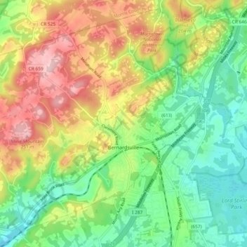
Name: Bernardsville topographic map, elevation, terrain.
Location: Bernardsville, Somerset County, New Jersey, United States (40.69287 -74.64098 40.75800 -74.54875)
Average elevation: 142 m
Minimum elevation: 58 m
Maximum elevation: 263 m
Bernardsville has a climate that borders between Humid continental and Humid subtropical with cool sometimes cold winters and warm to hot, humid summers on average. High elevations of the town have a warm summer humid continental climate with more snow during the winter and more orographic precipitation. Summer is the wettest season with frequent afternoon thunderstorms while Winter is the driest season.
Other topographic maps
Click on a map to view its topography, its elevation and its terrain.
Bridgewater Township
United States > New Jersey > Somerset County
Bridgewater Township, Somerset County, New Jersey, United States
Average elevation: 58 m
Basking Ridge
United States > New Jersey > Somerset County
Basking Ridge, Bernards Township, Somerset County, New Jersey, 02794, United States
Average elevation: 98 m
The Hills Development
United States > New Jersey > Somerset County
The Hills Development, Bernards Township, Somerset County, New Jersey, 06921, United States
Average elevation: 104 m
Bradley Gardens
United States > New Jersey > Somerset County > Bridgewater Township
Bradley Gardens, Bridgewater Township, Somerset County, New Jersey, 08869, United States
Average elevation: 28 m
Franklin Park Natural Area
United States > New Jersey > Somerset County > Franklin Township
Franklin Park Natural Area, Franklin Township, Somerset County, New Jersey, 08823, United States
Average elevation: 40 m
Blackwells Mills
United States > New Jersey > Somerset County > Franklin Township
Blackwells Mills, Franklin Township, Somerset County, New Jersey, 08823, United States
Average elevation: 24 m
Somerset
United States > New Jersey > Somerset County > Franklin Township
Somerset, Franklin Township, Somerset County, New Jersey, 08873, United States
Average elevation: 26 m
First Watchung Mountain
United States > New Jersey > Somerset County > Bridgewater Township
First Watchung Mountain, Bridgewater Township, Somerset County, New Jersey, 08836, United States
Average elevation: 55 m
Second Watchung Mountain
United States > New Jersey > Somerset County > Bridgewater Township
Second Watchung Mountain, Bridgewater Township, Somerset County, New Jersey, 08836, United States
Average elevation: 110 m
Warren Township
United States > New Jersey > Somerset County
Warren Township, Somerset County, New Jersey, United States
Average elevation: 94 m
Watchung
United States > New Jersey > Somerset County
Watchung, Somerset County, New Jersey, 07069, United States
Average elevation: 92 m
Pill Hill
United States > New Jersey > Somerset County > Bernardsville
Pill Hill, Bernardsville, Somerset County, New Jersey, 07939, United States
Average elevation: 121 m
Weston
United States > New Jersey > Somerset County > Manville
Weston, Manville, Somerset County, New Jersey, 08835, United States
Average elevation: 18 m
Gladstone
United States > New Jersey > Somerset County > Peapack-Gladstone
Gladstone, Peapack-Gladstone, Somerset County, New Jersey, 07934, United States
Average elevation: 113 m
Somerville
United States > New Jersey > Somerset County
Somerville, Somerset County, New Jersey, United States
Average elevation: 21 m
Green Brook
United States > New Jersey > Somerset County > Green Brook Township
Green Brook, Green Brook Township, Somerset County, New Jersey, 07063, United States
Average elevation: 43 m
Middlebush
United States > New Jersey > Somerset County > Franklin Township
Middlebush, Franklin Township, Somerset County, New Jersey, 08873, United States
Average elevation: 31 m
Dutchtown
United States > New Jersey > Somerset County > Montgomery Township
Dutchtown, Montgomery Township, Somerset County, New Jersey, 08558, United States
Average elevation: 49 m
Grandview
United States > New Jersey > Somerset County > Bridgewater Township
Grandview, Bridgewater Township, Somerset County, New Jersey, 08836, United States
Average elevation: 56 m
Springdale
United States > New Jersey > Somerset County
Springdale, Warren Township, Somerset County, New Jersey, 07059, United States
Average elevation: 103 m
Peapack-Gladstone
United States > New Jersey > Somerset County
Peapack-Gladstone, Somerset County, New Jersey, United States
Average elevation: 106 m
Branchburg Township
United States > New Jersey > Somerset County
Branchburg Township, Somerset County, New Jersey, United States
Average elevation: 42 m
Green Knoll
United States > New Jersey > Somerset County > Bridgewater Township
Green Knoll, Bridgewater Township, Somerset County, New Jersey, 08807, United States
Average elevation: 63 m
Round Top
United States > New Jersey > Somerset County
Round Top, Warren Township, Somerset County, New Jersey, 08836, United States
Average elevation: 128 m
Montgomery
United States > New Jersey > Somerset County > Montgomery
Montgomery, Montgomery Township, Somerset County, New Jersey, 08502, United States
Average elevation: 39 m
Bedminster
United States > New Jersey > Somerset County
Bedminster, Bedminster Township, Somerset County, New Jersey, 07931, United States
Average elevation: 67 m
Hillsborough Township
United States > New Jersey > Somerset County
Hillsborough Township, Somerset County, New Jersey, United States
Average elevation: 46 m
Woods Tavern
United States > New Jersey > Somerset County > Hillsborough Township
Woods Tavern, Hillsborough Township, Somerset County, New Jersey, 08844, United States
Average elevation: 28 m
Manville
United States > New Jersey > Somerset County
Manville, Somerset County, New Jersey, 08835, United States
Average elevation: 16 m
Voorhees
United States > New Jersey > Somerset County > Voorhees
Voorhees, Franklin Township, Somerset County, New Jersey, 08902, United States
Average elevation: 32 m
Millstone
United States > New Jersey > Somerset County > Millstone
Millstone, Somerset County, New Jersey, United States
Average elevation: 22 m
Franklin Township
United States > New Jersey > Somerset County
Franklin Township, Somerset County, New Jersey, United States
Average elevation: 31 m
North Plainfield
United States > New Jersey > Somerset County
North Plainfield, Somerset County, New Jersey, United States
Average elevation: 43 m
Warrenville
United States > New Jersey > Somerset County > Warrenville
Warrenville, Warren Township, Somerset County, New Jersey, 07059, United States
Average elevation: 112 m
Green Brook Township
United States > New Jersey > Somerset County
Green Brook Township, Somerset County, New Jersey, 08812, United States
Average elevation: 66 m
Finderne
United States > New Jersey > Somerset County > Finderne
Finderne, Bridgewater Township, Somerset County, New Jersey, 08890, United States
Average elevation: 24 m
Montgomery Township
United States > New Jersey > Somerset County
Montgomery Township, Somerset County, New Jersey, United States
Average elevation: 53 m
Skillman
United States > New Jersey > Somerset County > Montgomery Township
Skillman, Montgomery Township, Somerset County, New Jersey, 08558, United States
Average elevation: 56 m
Bedminster Township
United States > New Jersey > Somerset County
Bedminster Township, Somerset County, New Jersey, United States
Average elevation: 80 m
Bound Brook
United States > New Jersey > Somerset County
Bound Brook, Somerset County, New Jersey, 08805, United States
Average elevation: 24 m