
Make a donation
Rhonegletscher topographic map
Click on the map to display elevation.
Make a donation
About this map
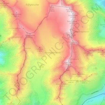
Name: Rhonegletscher topographic map, elevation, terrain.
Average elevation: 2,805 m
Minimum elevation: 1,884 m
Maximum elevation: 3,602 m
Make a donation
Other topographic maps
Click on a map to view its topography, its elevation and its terrain.
Oberwald
Switzerland > Wallis > Goms > Obergoms
It is situated at an elevation of 1,377 m and had a population of 277 in December 2007. It is located at the end of the Goms, directly before the Furka and Grimsel passes, underneath the Rhône River source at the Rhône Glacier. It is also the startpoint of the Furka Tunnel and is served by Oberwald railway…
Average elevation: 1,744 m
Make a donation
Oberwald
Switzerland > Wallis > Goms > Obergoms
It is situated at an elevation of 1,377 m and had a population of 277 in December 2007. It is located at the end of the Goms, directly before the Furka and Grimsel passes, underneath the Rhône River source at the Rhône Glacier. It is also the startpoint of the Furka Tunnel and is served by Oberwald railway…
Average elevation: 1,744 m