
L'Ayrolle topographic map
Interactive map
Click on the map to display elevation.
About this map
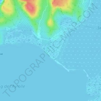
Name: L'Ayrolle topographic map, elevation, terrain.
Average elevation: 7 m
Minimum elevation: -2 m
Maximum elevation: 68 m
Other topographic maps
Click on a map to view its topography, its elevation and its terrain.
Plage du Grazel rive gauche - Poste de secours n°6
France > Occitanie > Aude > Gruissan
Plage du Grazel rive gauche - Poste de secours n°6, Discothèques, Gruissan, Narbonne, Aude, Occitanie, France métropolitaine, 11430, France
Average elevation: 4 m
Pech Rouge
France > Occitanie > Aude > Gruissan
Pech Rouge, Gruissan, Narbonne, Aude, Occitanie, France métropolitaine, 11430, France
Average elevation: 35 m