
Make a donation
Pánuco topographic map
Click on the map to display elevation.
Make a donation
About this map
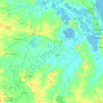
Name: Pánuco topographic map, elevation, terrain.
Location: Pánuco, Veracruz, Mexico (21.68941 -98.68155 22.47175 -97.89496)
Average elevation: 23 m
Minimum elevation: -2 m
Maximum elevation: 160 m
Make a donation
Other topographic maps
Click on a map to view its topography, its elevation and its terrain.
Isthmus of Tehuantepec
At its narrowest point, the isthmus is 200 km (124 mi) across from gulf to gulf, or 192 km (119 mi) to the head of Laguna Superior on the Pacific coast. The Sierra Madre del Sur mountain range breaks down at this point into a broad, plateau-like ridge, whose elevation, at the highest point reached by the…
Average elevation: 277 m
Make a donation
Make a donation
Córdoba
Córdoba is located in the center of the state of Veracruz, at 18º51'30" north latitude and 96º55'51" west longitude. It lies between the hills of Matlaquiahitl and Tepixtepec, at an elevation of 817 meters (2,680 feet) above mean sea level.
Average elevation: 1,030 m
Make a donation
Make a donation
Make a donation
Santa Clara (Camino a El Lienzo Charro)
Mexico > Veracruz > Córdoba > Córdoba
Average elevation: 973 m
Make a donation
La Angostura
Mexico > Veracruz > Atoyac > General Miguel Alemán (Potrero Nuevo) > La Angostura
Average elevation: 536 m
Make a donation
Ampliación las Bajadas
Mexico > Veracruz > Municipio de Veracruz > Las Bajadas > Ampliación las Bajadas
Average elevation: 17 m
Make a donation