
Thank you for supporting this site ❤️
Make a donation
Make a donation
Xhoris topographic map
Click on the map to display elevation.
Thank you for supporting this site ❤️
Make a donation
Make a donation
About this map
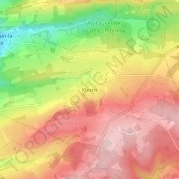
Name: Xhoris topographic map, elevation, terrain.
Location: Xhoris, Ferrières, Huy, Liège, Wallonie, 4190, Belgique (50.42398 5.58207 50.46398 5.62207)
Average elevation: 251 m
Minimum elevation: 114 m
Maximum elevation: 354 m
Thank you for supporting this site ❤️
Make a donation
Make a donation
Other topographic maps
Click on a map to view its topography, its elevation and its terrain.
Thank you for supporting this site ❤️
Make a donation
Make a donation