
Thank you for supporting this site ❤️
Make a donation
Make a donation
Céroux topographic map
Click on the map to display elevation.
Thank you for supporting this site ❤️
Make a donation
Make a donation
About this map
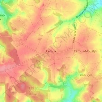
Name: Céroux topographic map, elevation, terrain.
Average elevation: 120 m
Minimum elevation: 68 m
Maximum elevation: 146 m
Thank you for supporting this site ❤️
Make a donation
Make a donation
Other topographic maps
Click on a map to view its topography, its elevation and its terrain.
Louvain-la-Neuve
Belgique > Brabant wallon > Nivelles > Ottignies-Louvain-la-Neuve
Average elevation: 123 m