
Thank you for supporting this site ❤️
Make a donation
Make a donation
Suxy topographic map
Click on the map to display elevation.
Thank you for supporting this site ❤️
Make a donation
Make a donation
About this map
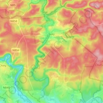
Name: Suxy topographic map, elevation, terrain.
Location: Suxy, Chiny, Virton, Luxembourg, Wallonie, 6812, Belgique (49.70830 5.37657 49.79047 5.45759)
Average elevation: 382 m
Minimum elevation: 303 m
Maximum elevation: 457 m
Thank you for supporting this site ❤️
Make a donation
Make a donation
Other topographic maps
Click on a map to view its topography, its elevation and its terrain.