
Thank you for supporting this site ❤️
Make a donation
Make a donation
Piney topographic map
Click on the map to display elevation.
Thank you for supporting this site ❤️
Make a donation
Make a donation
About this map
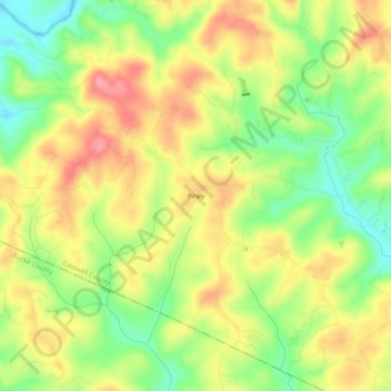
Name: Piney topographic map, elevation, terrain.
Location: Piney, Caldwell County, North Carolina, United States (35.85680 -81.69704 35.89680 -81.65704)
Average elevation: 377 m
Minimum elevation: 325 m
Maximum elevation: 426 m
Thank you for supporting this site ❤️
Make a donation
Make a donation
Other topographic maps
Click on a map to view its topography, its elevation and its terrain.