
Thank you for supporting this site ❤️
Make a donation
Make a donation
Thuneri topographic map
Click on the map to display elevation.
Thank you for supporting this site ❤️
Make a donation
Make a donation
About this map
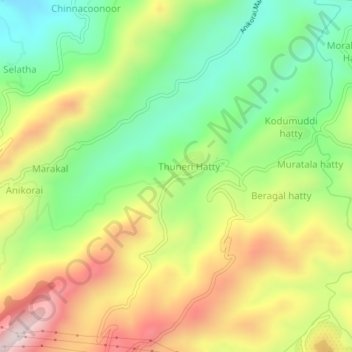
Name: Thuneri topographic map, elevation, terrain.
Location: Thuneri, Udhagamandalam, Nilgiris, Tamil Nadu, 643402, India (11.44022 76.73008 11.48022 76.77008)
Average elevation: 1,899 m
Minimum elevation: 1,638 m
Maximum elevation: 2,235 m
Thank you for supporting this site ❤️
Make a donation
Make a donation
Other topographic maps
Click on a map to view its topography, its elevation and its terrain.
Government Botanical Garden
India > Tamil Nadu > Udhagamandalam > Udhagamandalam
Average elevation: 2,325 m