
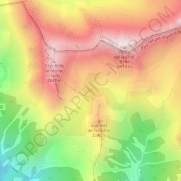
Lac de Souliers topographic map
Interactive map
Click on the map to display elevation.
About this map
Name: Lac de Souliers topographic map, elevation, terrain.
Average elevation: 2,435 m
Minimum elevation: 1,874 m
Maximum elevation: 2,892 m
Other topographic maps
Click on a map to view its topography, its elevation and its terrain.
Montbardon
France > Provence-Alpes-Côte d'Azur > Hautes-Alpes > Château-Ville-Vieille
Average elevation: 1,724 m
Les Meyries
France > Provence-Alpes-Côte d'Azur > Hautes-Alpes > Château-Ville-Vieille > Château-Queyras
Average elevation: 1,771 m
Ville-Vieille
France > Provence-Alpes-Côte d'Azur > Hautes-Alpes > Château-Ville-Vieille
Average elevation: 1,733 m
Prats Hauts
France > Provence-Alpes-Côte d'Azur > Hautes-Alpes > Château-Ville-Vieille
Average elevation: 1,882 m
Prats Bas
France > Provence-Alpes-Côte d'Azur > Hautes-Alpes > Château-Ville-Vieille > Ville-Vieille
Average elevation: 1,840 m
Le Brasq
France > Provence-Alpes-Côte d'Azur > Hautes-Alpes > Château-Ville-Vieille > Ville-Vieille
Average elevation: 1,720 m
Souliers
France > Provence-Alpes-Côte d'Azur > Hautes-Alpes > Château-Ville-Vieille
Average elevation: 1,923 m
La Casse
France > Provence-Alpes-Côte d'Azur > Hautes-Alpes > Château-Ville-Vieille > Ville-Vieille
Average elevation: 1,744 m