
Zaffelare topographic map
Interactive map
Click on the map to display elevation.
About this map
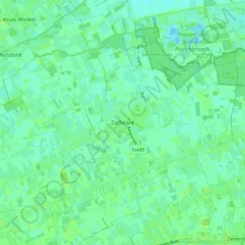
Name: Zaffelare topographic map, elevation, terrain.
Location: Zaffelare, Lochristi, Gent, Oost-Vlaanderen, België (51.11521 3.81685 51.14947 3.89910)
Average elevation: 5 m
Minimum elevation: -3 m
Maximum elevation: 8 m
Other topographic maps
Click on a map to view its topography, its elevation and its terrain.
Lobos
België > Oost-Vlaanderen > Gent > Lochristi
Lobos, Lochristi, Gent, Oost-Vlaanderen, 9080, België
Average elevation: 6 m
Lochristi
België > Oost-Vlaanderen > Gent > Lochristi
Lochristi, Gent, Oost-Vlaanderen, 9080, België
Average elevation: 6 m
Lozen Boer
België > Oost-Vlaanderen > Gent > Lochristi
Lozen Boer, Lochristi, Gent, Oost-Vlaanderen, 9080, België
Average elevation: 5 m
Beervelde
België > Oost-Vlaanderen > Gent > Lochristi
Beervelde, Lochristi, Gent, Oost-Vlaanderen, België
Average elevation: 6 m
Zeveneken
België > Oost-Vlaanderen > Gent > Lochristi
Zeveneken, Lochristi, Gent, Oost-Vlaanderen, Vlaanderen, België
Average elevation: 5 m
Hijfte
België > Oost-Vlaanderen > Gent > Lochristi
Hijfte, Lochristi, Gent, Oost-Vlaanderen, Vlaanderen, 9080, België
Average elevation: 6 m