
Town of Putnam Valley topographic map
Interactive map
Click on the map to display elevation.
About this map
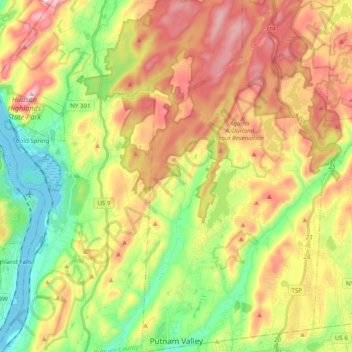
Name: Town of Putnam Valley topographic map, elevation, terrain.
Average elevation: 194 m
Minimum elevation: -1 m
Maximum elevation: 431 m
Other topographic maps
Click on a map to view its topography, its elevation and its terrain.
Kent Hills
United States > New York > Putnam County
Kent Hills, Town of Kent, Putnam County, New York, 10512, United States
Average elevation: 250 m
Ludingtonville
United States > New York > Putnam County > Kent Hills
Ludingtonville, Kent Hills, Town of Kent, Putnam County, New York, 10512, United States
Average elevation: 258 m
Brewster Hill
United States > New York > Putnam County
Brewster Hill, Town of Southeast, Putnam County, New York, 10509, United States
Average elevation: 154 m