
Thank you for supporting this site ❤️
Make a donation
Make a donation
Gaura topographic map
Click on the map to display elevation.
Thank you for supporting this site ❤️
Make a donation
Make a donation
About this map
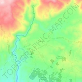
Name: Gaura topographic map, elevation, terrain.
Average elevation: 156 m
Minimum elevation: 28 m
Maximum elevation: 334 m
Thank you for supporting this site ❤️
Make a donation
Make a donation
Other topographic maps
Click on a map to view its topography, its elevation and its terrain.
Taman Gelora
Indonesia > East Nusa Tenggara > Sumba Barat > Waikabubak > Kampung Ngadu Motora
Average elevation: 417 m