
Thank you for supporting this site ❤️
Make a donation
Make a donation
Arung Ayam topographic map
Click on the map to display elevation.
Thank you for supporting this site ❤️
Make a donation
Make a donation
About this map
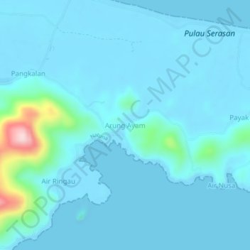
Name: Arung Ayam topographic map, elevation, terrain.
Location: Arung Ayam, Natuna, Riau Islands, Sumatra, Indonesia (2.48589 109.03602 2.52589 109.07602)
Average elevation: 26 m
Minimum elevation: -1 m
Maximum elevation: 299 m
Thank you for supporting this site ❤️
Make a donation
Make a donation
Other topographic maps
Click on a map to view its topography, its elevation and its terrain.