
De Driekoningen topographic map
Interactive map
Click on the map to display elevation.
About this map
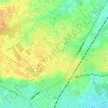
Name: De Driekoningen topographic map, elevation, terrain.
Average elevation: 28 m
Minimum elevation: 14 m
Maximum elevation: 43 m
Other topographic maps
Click on a map to view its topography, its elevation and its terrain.
Torhout
België > West-Vlaanderen > Brugge > Torhout
Torhout, Brugge, West-Vlaanderen, Vlaanderen, 8820, België
Average elevation: 22 m
Wijnendale
België > West-Vlaanderen > Brugge > Torhout
Wijnendale, Torhout, Brugge, West-Vlaanderen, 8211, België
Average elevation: 32 m