
Châtillens topographic map
Interactive map
Click on the map to display elevation.
About this map
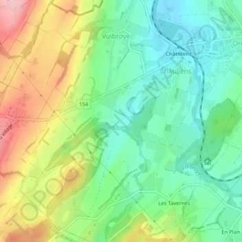
Name: Châtillens topographic map, elevation, terrain.
Location: Châtillens, Oron, District de Lavaux-Oron, Vaud, 1610, Suisse (46.55125 6.78968 46.57318 6.81934)
Average elevation: 660 m
Minimum elevation: 598 m
Maximum elevation: 763 m
Other topographic maps
Click on a map to view its topography, its elevation and its terrain.
Oron-la-Ville
Oron-la-Ville, Oron, District de Lavaux-Oron, Vaud, 1610, Suisse
Average elevation: 657 m
Les Thioleyres
Les Thioleyres, Oron, District de Lavaux-Oron, Vaud, 1607, Suisse
Average elevation: 683 m
Château d'Oron
Château d'Oron, 1, Route de Bulle, Oron-le-Châtel, Oron, District de Lavaux-Oron, Vaud, 1608, Suisse
Average elevation: 701 m