
Thank you for supporting this site ❤️
Make a donation
Make a donation
Palabuhanratu topographic map
Click on the map to display elevation.
Thank you for supporting this site ❤️
Make a donation
Make a donation
About this map
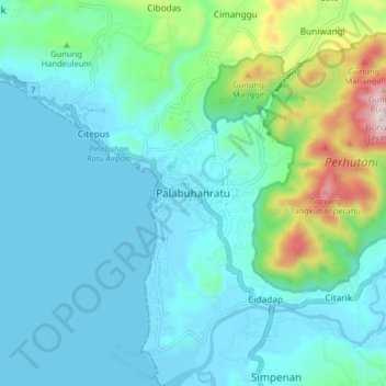
Name: Palabuhanratu topographic map, elevation, terrain.
Location: Palabuhanratu, Sukabumi, West Java, Java, 43364, Indonesia (-7.02824 106.51037 -6.94824 106.59037)
Average elevation: 119 m
Minimum elevation: -4 m
Maximum elevation: 666 m
Thank you for supporting this site ❤️
Make a donation
Make a donation
Other topographic maps
Click on a map to view its topography, its elevation and its terrain.