
Cauterets topographic map
Click on the map to display elevation.
Cauterets
The minimum altitude, 503 metres (1,650 ft), is located in the north, where the Gave de Cauterets leaves the communal area and enters that of Soulom. The maximum elevation of 3,298 metres (10,820 ft) corresponds to the highest point of the French Pyrénées, Vignemale, marking the border with Spain [fr]. Other summits in the neighbourhood include the Monné at 2,723 metres (8,934 ft), the Cabaliros at 2,333 metres (7,654 ft) and the Pic de Chabarrou at 2,910 metres (9,550 ft).
About this map
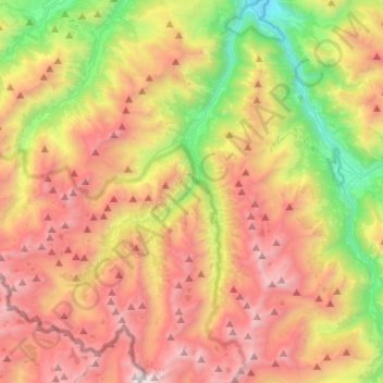
Name: Cauterets topographic map, elevation, terrain.
Average elevation: 1,817 m
Minimum elevation: 466 m
Maximum elevation: 3,265 m
Other topographic maps
Click on a map to view its topography, its elevation and its terrain.
Luz-Saint-Sauveur
France > Occitania > Hautes Pyrenees > Luz-Saint-Sauveur > Luz-Saint-Sauveur
Average elevation: 1,035 m
Cazaux-Debat
France > Occitania > Hautes Pyrenees > Cazaux-Fréchet-Anéran-Camors
Average elevation: 1,324 m