
Thank you for supporting this site ❤️
Make a donation
Make a donation
Harlech topographic map
Click on the map to display elevation.
Thank you for supporting this site ❤️
Make a donation
Make a donation
About this map
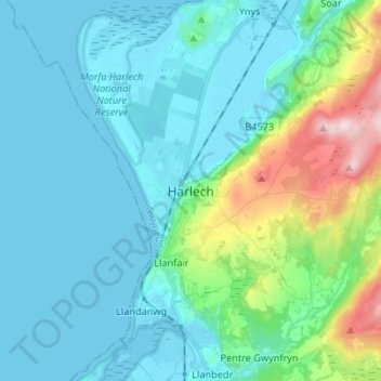
Name: Harlech topographic map, elevation, terrain.
Location: Harlech, Gwynedd, Wales, LL46 2YE, United Kingdom (52.81877 -4.14745 52.89877 -4.06745)
Average elevation: 68 m
Minimum elevation: -1 m
Maximum elevation: 383 m
Thank you for supporting this site ❤️
Make a donation
Make a donation
Other topographic maps
Click on a map to view its topography, its elevation and its terrain.