
Thank you for supporting this site ❤️
Make a donation
Make a donation
West Lancashire topographic map
Click on the map to display elevation.
Thank you for supporting this site ❤️
Make a donation
Make a donation
About this map
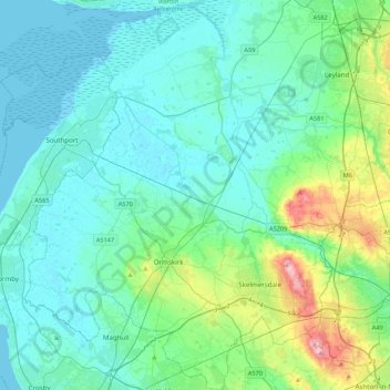
Name: West Lancashire topographic map, elevation, terrain.
Location: West Lancashire, Lancashire, England, United Kingdom (53.48276 -3.08455 53.73921 -2.68931)
Average elevation: 30 m
Minimum elevation: 0 m
Maximum elevation: 179 m
Thank you for supporting this site ❤️
Make a donation
Make a donation
Other topographic maps
Click on a map to view its topography, its elevation and its terrain.