
Thank you for supporting this site ❤️
Make a donation
Make a donation
Rocktail Beach Camp topographic map
Click on the map to display elevation.
Thank you for supporting this site ❤️
Make a donation
Make a donation
About this map
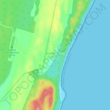
Name: Rocktail Beach Camp topographic map, elevation, terrain.
Average elevation: 35 m
Minimum elevation: -2 m
Maximum elevation: 141 m
Thank you for supporting this site ❤️
Make a donation
Make a donation
Other topographic maps
Click on a map to view its topography, its elevation and its terrain.
uMhlabuyalingana Ward 17
South Africa > KwaZulu-Natal > Umkhanyakude District Municipality > uMhlabuyalingana Local Municipality
Average elevation: 57 m