
Thank you for supporting this site ❤️
Make a donation
Make a donation
Santa Lucia topographic map
Click on the map to display elevation.
Thank you for supporting this site ❤️
Make a donation
Make a donation
About this map
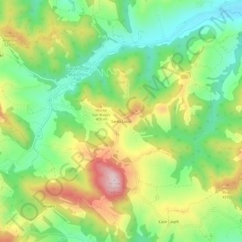
Name: Santa Lucia topographic map, elevation, terrain.
Average elevation: 322 m
Minimum elevation: 174 m
Maximum elevation: 541 m
Thank you for supporting this site ❤️
Make a donation
Make a donation
Other topographic maps
Click on a map to view its topography, its elevation and its terrain.
Castello di Varano Marchesi
Italia > Emilia-Romagna > Parma > Varano Dei Marchesi
Average elevation: 314 m