
Make a donation
Sekong Province topographic map
Click on the map to display elevation.
Make a donation
Sekong Province
The Dakchung Plateau is an Important Bird Area (IBA). It is 5,140 ha in size, and at an elevation of 800–1,400 metres (2,600–4,600 ft). The habitat is characterized as pine woodland, grassland, degraded semi-evergreen forest, dry evergreen forest, marshy land, and tall grasses areas. Of the avifauna, the yellow-billed nuthatch (Sitta solangiae) is classified as near threatened, while the black-crowned barwing (Actinodura sodangorum) is classified as vulnerable. Other fauna include the Oriental small-clawed otter (Aonyx cinerea), tiger (Panthera tigris), big-headed turtle (Platysternon megacephalum), and herds of Asian elephant (Elephas maximus).
Make a donation
About this map
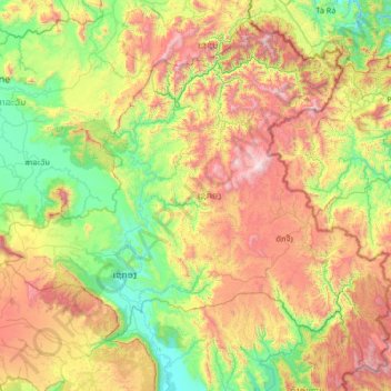
Name: Sekong Province topographic map, elevation, terrain.
Location: Sekong Province, Laos (15.02836 106.30008 16.18952 107.63500)
Average elevation: 771 m
Minimum elevation: 94 m
Maximum elevation: 2,170 m
Make a donation
Other topographic maps
Click on a map to view its topography, its elevation and its terrain.
Make a donation
B. Haysok
Laos > Vientiane Prefecture > Chanthabuly District > Vientiane Capital
Average elevation: 170 m
Make a donation
Make a donation
Saphangmo
Laos > Vientiane Prefecture > Xaysetha District > Vientiane Capital
Average elevation: 170 m
Make a donation
Donnokkhoum
Laos > Vientiane Prefecture > Sisattanak District > Vientiane Capital
Average elevation: 170 m
Phonsinouan
Laos > Vientiane Prefecture > Sisattanak District > Vientiane Capital
Average elevation: 170 m
Make a donation
Nongtaeng
Laos > Vientiane Prefecture > Sikhottabong District > Vientiane Capital
Average elevation: 174 m
Make a donation
Dongkhamxang
Laos > Vientiane Prefecture > Hadxayfong District > Vientiane Capital
Average elevation: 172 m
Nonghai
Laos > Vientiane Prefecture > Hadxayfong District > Vientiane Capital
Average elevation: 172 m
Make a donation
Muangvatha
Laos > Vientiane Prefecture > Sikhottabong District > Vientiane Capital
Average elevation: 169 m
Dognaxoyneua
Laos > Vientiane Prefecture > Sikhottabong District > Vientiane Capital
Average elevation: 169 m
Make a donation
ທົ່ງປົງ
Laos > Vientiane Prefecture > Sikhottabong District > Vientiane Capital
Average elevation: 174 m
Make a donation
Nongtha Marsh
Laos > Vientiane Prefecture > Chanthabuly District > Vientiane Capital > B. Nongthanua
Average elevation: 175 m
Don Koy
Laos > Vientiane Prefecture > Sisattanak District > Vientiane Capital
Average elevation: 169 m
Chommanytai
Laos > Vientiane Prefecture > Xaysetha District > Vientiane Capital
Average elevation: 172 m
Make a donation
Make a donation
Make a donation
Dongphosy
Laos > Vientiane Prefecture > Hadxayfong District > Vientiane Capital
Average elevation: 168 m
Make a donation
Make a donation
Make a donation
Make a donation
Make a donation
Make a donation
Thatlouangkang
Laos > Vientiane Prefecture > Xaysetha District > Vientiane Capital
Average elevation: 170 m
Make a donation
Make a donation
Make a donation
Xiangkhouang
Xiangkhouang province covers an area of 15,880 square kilometres (6,130 sq mi) and is mountainous. Apart from floodplains, the largest area of level land in the country is on the province's Xiangkhoang Plateau. The plateau is characterized by rolling hills and grassland whose elevation averages 1,300 metres…
Average elevation: 565 m
Make a donation
Sibounheuang
Laos > Vientiane Prefecture > Chanthabuly District > Sibounheuang
Average elevation: 171 m
Make a donation
Make a donation
Make a donation