
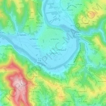
Le Peyssis topographic map
Interactive map
Click on the map to display elevation.
About this map
Name: Le Peyssis topographic map, elevation, terrain.
Average elevation: 263 m
Minimum elevation: 179 m
Maximum elevation: 459 m
Other topographic maps
Click on a map to view its topography, its elevation and its terrain.
Penchot
France > Occitanie > Aveyron > Livinhac-le-Haut
Penchot, Livinhac-le-Haut, Villefranche-de-Rouergue, Aveyron, Occitanie, France métropolitaine, 12300, France
Average elevation: 327 m
Le Petit
France > Occitanie > Aveyron > Livinhac-le-Haut
Le Petit, Livinhac-le-Haut, Villefranche-de-Rouergue, Aveyron, Occitanie, France métropolitaine, 12300, France
Average elevation: 249 m
Feydel Haut
France > Occitanie > Aveyron > Livinhac-le-Haut
Feydel Haut, Livinhac-le-Haut, Villefranche-de-Rouergue, Aveyron, Occitanie, France métropolitaine, 12300, France
Average elevation: 317 m