
Thank you for supporting this site ❤️
Make a donation
Make a donation
Parc national de Forillon topographic map
Click on the map to display elevation.
Thank you for supporting this site ❤️
Make a donation
Make a donation
About this map
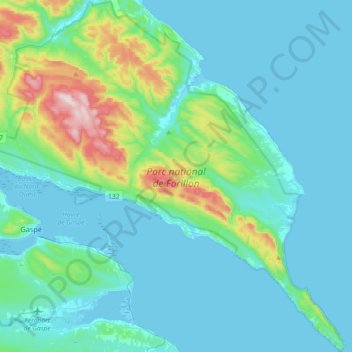
Name: Parc national de Forillon topographic map, elevation, terrain.
Average elevation: 82 m
Minimum elevation: -2 m
Maximum elevation: 550 m
Thank you for supporting this site ❤️
Make a donation
Make a donation
Other topographic maps
Click on a map to view its topography, its elevation and its terrain.
Parc de la rue Gauthier
Canada > Quebec > La Côte-de-Gaspé > Gaspé > Val-Renard
Average elevation: 90 m
Thank you for supporting this site ❤️
Make a donation
Make a donation