Thank you for supporting this site ❤️
Make a donation
Make a donation
Duit topographic map
Click on the map to display elevation.
Thank you for supporting this site ❤️
Make a donation
Make a donation
About this map
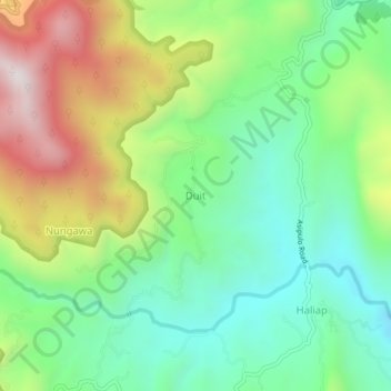
Name: Duit topographic map, elevation, terrain.
Location: Duit, Ifugao, Cordillera Administrative Region, Philippines (16.72737 121.05881 16.76737 121.09881)
Average elevation: 888 m
Minimum elevation: 564 m
Maximum elevation: 1,455 m
Thank you for supporting this site ❤️
Make a donation
Make a donation
Other topographic maps
Click on a map to view its topography, its elevation and its terrain.
Thank you for supporting this site ❤️
Make a donation
Make a donation
Thank you for supporting this site ❤️
Make a donation
Make a donation
Thank you for supporting this site ❤️
Make a donation
Make a donation
