
Monfragüe topographic map
Interactive map
Click on the map to display elevation.
About this map
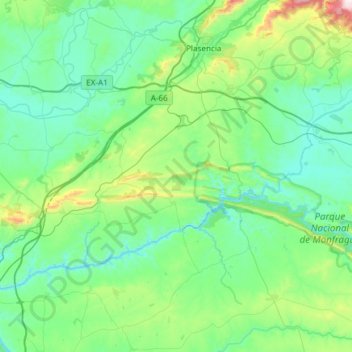
Name: Monfragüe topographic map, elevation, terrain.
Location: Monfragüe, Cáceres, Extremadura, España (39.66088 -6.45399 40.06468 -5.85647)
Average elevation: 369 m
Minimum elevation: 198 m
Maximum elevation: 1,266 m
Other topographic maps
Click on a map to view its topography, its elevation and its terrain.
Parque Nacional de Monfragüe
España > Extremadura > Torrejón el Rubio
Parque Nacional de Monfragüe, Calleja larga, Torrejón el Rubio, Cáceres, Extremadura, España
Average elevation: 351 m
Belloto
España > Extremadura > Campanario
Belloto, Campanario, Badajoz, Extremadura, 06460, España
Average elevation: 414 m