
Thank you for supporting this site ❤️
Make a donation
Make a donation
Catoosa topographic map
Click on the map to display elevation.
Thank you for supporting this site ❤️
Make a donation
Make a donation
About this map
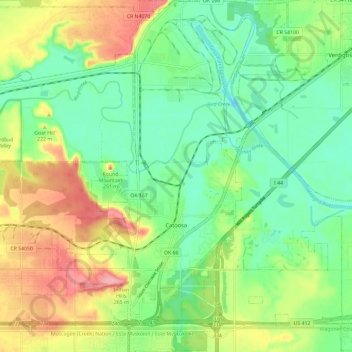
Name: Catoosa topographic map, elevation, terrain.
Location: Catoosa, Rogers County, Oklahoma, United States (36.15480 -95.81540 36.24949 -95.71740)
Average elevation: 195 m
Minimum elevation: 154 m
Maximum elevation: 263 m
Thank you for supporting this site ❤️
Make a donation
Make a donation
Other topographic maps
Click on a map to view its topography, its elevation and its terrain.