
Make a donation
Dinosaur National Monument topographic map
Click on the map to display elevation.
Make a donation
Dinosaur National Monument
Originally preserved in 1915 to protect its famous Dinosaur Quarry, the monument was greatly expanded in 1938 to include its wealth of natural history. The park's wild landscapes, topography, geology, paleontology, and history make it a unique resource for both science and recreation. The park contains over 800 paleontological sites and has fossils of dinosaurs including Allosaurus, Deinonychus, Abydosaurus, and various sauropods. The Abydosaurus consists of a nearly complete skull, the lower jaw, and first four neck vertebrae. The specimen was found at the base of the Mussentuchit Member of the Cedar Mountain Formation and is the holotype for the description.
Make a donation
About this map
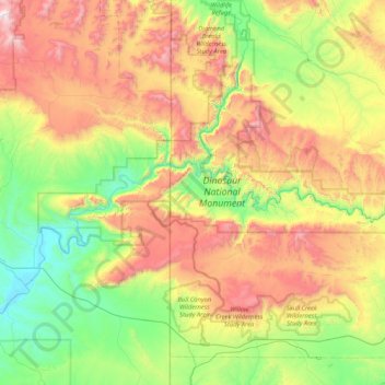
Name: Dinosaur National Monument topographic map, elevation, terrain.
Average elevation: 1,988 m
Minimum elevation: 1,437 m
Maximum elevation: 2,955 m
Make a donation
Other topographic maps
Click on a map to view its topography, its elevation and its terrain.