
Thank you for supporting this site ❤️
Make a donation
Make a donation
Centerville topographic map
Click on the map to display elevation.
Thank you for supporting this site ❤️
Make a donation
Make a donation
Centerville
In 1913, Centerville sustained minimal damage during the Great Flood of 1913 due to its relatively high elevation. The city sits on one of the highest points in Montgomery County.
Thank you for supporting this site ❤️
Make a donation
Make a donation
About this map
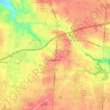
Name: Centerville topographic map, elevation, terrain.
Location: Centerville, Montgomery County, Ohio, United States (39.59062 -84.20869 39.67385 -84.09909)
Average elevation: 287 m
Minimum elevation: 226 m
Maximum elevation: 323 m
Thank you for supporting this site ❤️
Make a donation
Make a donation
Other topographic maps
Click on a map to view its topography, its elevation and its terrain.
Thank you for supporting this site ❤️
Make a donation
Make a donation
Thank you for supporting this site ❤️
Make a donation
Make a donation
Thank you for supporting this site ❤️
Make a donation
Make a donation