
Make a donation
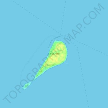
Kavaratti topographic map
Click on the map to display elevation.
Make a donation
Kavaratti
The atoll of Kavaratti lies 360 km (220 mi) off the Malabar coast of mainland India. The island is 5.6 km (3.5 mi) long, and 1.6 km (0.99 mi) wide, and occupies an area of 4.22 km2 (1.63 sq mi). It is surrounded by a 6 km (3.7 mi) long lagoon with an area of 4.96 km2 (1.92 sq mi). It is located to the east of Agatti and to the west of Andrott islands. The island gently slopes from the west to east, with an average altitude of 2 to 5 m (6 ft 7 in to 16 ft 5 in) on the west and 2 to 3 m (6 ft 7 in to 9 ft 10 in) on the eastern side. The soil is mostly sandy or loamy. Kavaratti has an inland lake in the northern part of the island and numerous small ponds and wells. The island is surrounded by coral reefs that support various marine life.
Make a donation
About this map
Name: Kavaratti topographic map, elevation, terrain.
Location: Kavaratti, Lakshadweep, 262240, India (10.52722 72.59946 10.60722 72.67946)
Average elevation: 0 m
Minimum elevation: 0 m
Maximum elevation: 17 m
Make a donation
Other topographic maps
Click on a map to view its topography, its elevation and its terrain.
Kavaratti Island
India > Lakshadweep > Kavaratti > Kavaratti
The island of Kavaratti lies 360 km (190 nmi) off the coast of the state of Kerala at 10°34′N 72°38′E / 10.57°N 72.64°E / 10.57; 72.64. It has an average elevation of 0 metres (0 feet).
Average elevation: 2 m